
Page 34 - Studia Universitatis Hereditati, vol 13(2) (2025)
P. 34
34
studia universitatis hereditati, letnik 13 (2025), številka 2 / volume 13 (2025), number 2
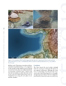
Figure 12: Documentation of the Boat Moorings in the Bijar Bay and a Comparison of Their Location and a Hy-
pothetical Roman Sea Level (–1.5 m) Marked by a White Dashed Line (elaborated by Martin Fera, 2025, and Neno
Starčić, 2024)
by Faber (1980). They were re-recorded and docu- Conclusion
mented during fieldwork (fig. 12). A comparison The Osor beyond the myth project emerged
of the location of the bollards and the Roman from the necessity to reinterpret the history of
sea level shows that they were indeed suitable for this regional trading port. Although the main
securing ships in Roman times. However, this focus is archaeology, it has become clear in re-
does not necessarily mean that they were carved cent decades that archaeology alone is incapable
at that time, as local diver Neno Starčić sums up: of capturing all the factors that have shaped the
‘People have been using the same places to an- place’s history. Given its location as a coastal city,
chor for centuries.’