
Page 72 - Studia Universitatis Hereditati, vol 12(2) (2024)
P. 72
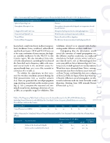
Table 1. Environmental Sound Propagation Factors that are Included in the SPreAD-GIS Calculation Process
                Environmental sound propagation factors  Declining the sound level due to…
                Spherical Spreading Loss                 Distance
                Atmospheric Absorption Loss              Atmospheric absorption which depends on temperature, humid-
                                                         ity and elevation
                Foliage and Ground Cover Loss            Absorption by the ground and scattering by vegetation
                Downwind and Upwind Loss                 Wind direction, wind speed, seasonal conditions
                Terrain Effects                          Barrier effects from hills or ridgelines
                Predicted Noise Propagation              The difference between introduced and background levels


               barren land, coniferous forest, herbaceous/grass-  validation allowed us to proceed with further
        72     land, deciduous forest, scrubland, urban/devel-  testing under different weather conditions.
               oped land, and water. DEM and NLCD were set     Anticipating that the simulations would
        studia universitatis hereditati, letnik 12 (2024), številka 2 / volume 12 (2024), number 2
               at the same resolution of 10x10 meters, the high-  reveal the extremes of sound propagation un-
               est available resolution for the NLCD in this   der different weather conditions, we conducted
               Catalan region. We also introduced data relat-  simulations for both extreme winter and sum-
               ed to the sound source, including the location of   mer days (B and C, tab. 4). Meteorological data
               the Àneu bell and a frequency table with meas-  were sourced from Servei Meteorològic de Cata-
               ured sound  levels in  the one-third  octave fre-  lunya (n.d.), including data from nearby stations.
               quency bands from 400–2000 Hz, recorded at   Wind data were obtained from Tírvia, extreme
               a distance of 11 m (tab. 2).                temperature data from the last 50 years were tak-
                   To validate the simulation, we first recre-  en from Tremp, and humidity data were collect-
               ated the weather conditions present during the   ed from La Pobla de Segur. Given that wind sig-
               field measurements (tab. 4, weather scenario   nificantly influences sound propagation, we also
               A.1). Then, we generated the sound propagation   tested conditions with the most favorable wind
               map, showing sound levels at the receiver points   direction, blowing from SSE towards Esterri
               (fig. 5). Tab. 3 compares the measured and sim-  d’Àneu (tab. 4, A.2.).
               ulated sound levels, showing a deviation of 3 to
               4 dBA, an acceptable range for validation. This


               Table 2. The Frequency Table Used to Characterize the Sound Source for the SPreAD-GIS Simulation,
               Including Sound Pressure Levels (dBA) in the One-third Octave Frequency Bands from 400–2000 Hz,
               Recorded at 11 m from the Source.

                Frequency (Hz)           400     500     630     800    1000     1250   1600    2000
                Sound Pressure Level (dBA)  47    73      69      70      81      80      76      80
               Table 3. Measured vs. Simulated Values of Sound Pressure Levels for Two Receiver Points on the Site of Santa Maria
               d’Àneu
                                                              Measured values  (L AF; dBA)  Simulated val-
                Receiver ID  Receiver location
                                                             1st toll   2nd toll    3rd toll  ues (dBA)
                1          In front of the church and bell gable  81.7    80.3       90.7 85
                2          On the earthen road behind the church  60.2     53.3       56.2 64