
Page 47 - Studia Universitatis Hereditati, vol 13(2) (2025)
P. 47
(settlement, enclosure) than in previous stud- al location, layout and purpose of enclosed set-
ies. The result is illustrated in figure 2. The lo- tlements without systematic use of prospection
cations/sites were grouped into three categories: methods and excavations. Secondly, the pre-
sites documented only in regional publications; sumed hillforts could be hidden beneath the
sites mapped only using high-resolution ALS modern settlements, as in the case of Beli (9).
data; and sites reported in literature with vis- Thirdly, some of the settlements referred to by
ible dry stone wall remains in the remote sens- Marchesetti (1924) are now partially or whol-
ing data. Sites that did not meet the criteria of at ly occupied by military installations (see, for in-
least two of these categories (e.g. ALS structures stance, the levelled plateau on M. Telegrafo (76))
and datable finds from trial excavations/unsys- or obscured by subsequent land use (for instance
tematic surveys) were marked with a question 11, 15, 19, 54, 58, 73 or 80). Other presumed hill-
mark. This applies to the majority of the hilltop forts, such as Jablanac on the island of Cres –
settlements recorded by Marchesetti (1924). In where, according to Ćus-Rukonić et al. (2013, 11), 47
elevated areas with no clear defensive structures a ‘signaling and monitoring station’ is expected
other than simple enclosures, the distinction be- to be situated – were not included in the list at
tween agro-pastoral use and archaeologically de- all due to a lack of supporting evidence.
fined fortified settlements was not always clear. In terms of geographical distribution, more
Therefore, simple enclosures for which no data- than half of the presumed hillfort and enclosure
ble finds were available were generally designat- sites (46 out of 85) are located on the island of
ed as ‘enclosures’. However, where the features Cres. Another 28 sites are found on the island
in the ALS data were extremely distinct and/or of Lošinj, and a further 12 are located on small-
datable finds mentioned in the literature, the en- er islands. A clear concentration can be seen on
closures were defined fortified settlements. The Cres in the topographically higher regions in
term ‘settlement’ is used in the broadest sense the north, as well as around Lake Vrana. In con-
to refer to human habitation in permanent dry trast, the southern half of Cres, including Pun-
stone walled structures, without discussing the ta Križa, has a sparse distribution. The highest
function of the individual locations. For this dis- density of sites is found on the narrow, rugged is-
cussion, we believe that systematic research in- land of Lošinj.
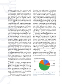
cluding meaningful dating is needed, as it can The classification of the topographical loca-
be assumed that the same hills could have ful- tion paints a diverse picture: only slightly more Up and Down the Hill: Hillforts and Dry Stone Wall Enclosures on the Kvarner Islands...
filled different functions over time. Therefore, than half are designated as hilltop locations (fig.
the list of 85 locations is not equivalent to the 3). The rest are located on small hills, mountain
same number of (prehistoric) hillforts; it mere-
ly comprises locations where hillfort settlements
and other types of enclosure were systematical-
ly reviewed.
There is an obvious discrepancy between
the locations of the hillfort settlements men-
tioned in the literature and those revealed by
the analysis of ALS data, as only 35 have visible
structures in the DTM; for the remaining 22 lo-
cations, this was not the case. Of the sites men-
tioned in the literature, only 50% showed clear
fortification structures in the DTM. Figure 3: Pie Chart Listing the Actual Topographic Po-
There are various reasons for this outcome. sition of the Documented Sites (elaborated by Martin
Firstly, it is challenging to identify the actu- Fera, 2025)