
Page 50 - Studia Universitatis Hereditati, vol 13(2) (2025)
P. 50
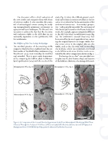
The discussion offers a brief evaluation of   study (fig. 7). Given the difficult ground condi-
               the new results and compares them with those   tions and technical resources available in the late
               of previous studies. It also considers the poten-  1960s, it is evident that his documentation of the
               tial of archaeological remote sensing for study-  settlement features was – from today´s perspec-
               ing topographically prominent settlements in   tive – only partially successful. The settlement of
               agro-pastoral karst landscapes. To this end, it is   Vela Straža (48) located on the Punta Križa Pen-
               necessary to address the fact that the dry stone   insula, for example, appears completely different
               wall enclosures visible in the ALS data are not   in the ALS data than on well-known maps (fig.
               necessarily equivalent to the (prehistoric) hill-  7a). The settlement’s unusual shape may have
               fort settlements.                           been caused by the area’s agricultural use, mean-
                                                           ing the original layout is no longer visible. Fur-
               The Hillforts of the Cres-Lošinj Archipelago  ther minor errors in the original plan are also
        50     The  standard  practice  of  documenting  visible   visible, such as the dry stone wall surrounding
               ramparts, which has been employed since the ear-  the sinkhole, which was mistakenly attributed
               liest studies of fortified hilltop settlements (e.g.   to the hillfort at the time. Similar results are re-
        studia universitatis hereditati, letnik 13 (2025), številka 2 / volume 13 (2025), number 2
               Marchesetti 1924), must nowadays be modified   vealed by the other comparisons shown in fig. 7.
               and extended. This is most easily demonstrat-   Evaluating the 500 km² area provided new
               ed by comparing the hillfort plans in Mirosav-  insights into the distribution, shape and location
               ljević’s publication (1974) with the results of this   of the hillforts. However, the dating of the indi-


               Figure 7: A Comparison of the Ground Plans (in Approximate Scale) From Mirosavljević’s Work (1974) With Those
               Obtained Through the Analysis of ALS Data: a) Vela straža (48); b) Skulka (26); c) Jelovica (32) and d) Pelginja (20)
               (background data: DTM HR (https://dgu.gov.hr/); elaborated by Martin Fera, 2025)