
Page 52 - Studia Universitatis Hereditati, vol 13(2) (2025)
P. 52
been found in the ALS data. The location has
been defined as a burial site in a recent publica-
tion (Blečić Kavur and Kavur 2024, 26–8).
From Hillforts to Landscapes
Geographically, the archipelago belongs to
the typical Dinaric karst landscape (Fuerst-
Bjeliš et al. 2024). This is characterised by
dry stone walls that serve various settlement
and agro-pastoral purposes, such as enclosing
slope terraces, sinkholes, and agricultural land
(Kremenić et al. 2021; Andlar et al. 2018). To
52 adequately address the specific archaeological
remains amidst this complexity, archaeologi-
cal methods capable of handling extensive and
studia universitatis hereditati, letnik 13 (2025), številka 2 / volume 13 (2025), number 2
complex data sets are required. This primari-
ly involves landscape archaeology, which cov-
ers a wide range of topics (e.g. Doneus and Do-
neus Forthcoming). A key aspect of landscape
archaeology is providing a comprehensive, di-
achronic, large-scale description of the loca-
tion, extent, character, and chronological se-
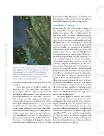
Figure 8: Gračišće Ustrine (38), Sv. Mihovil (39), Kuši quence of material remains. Archaeological
(40), Ognjarice (41), Peščenji (42), Bog (43), Kalćić (45), prospection is the first step in this process, as
Bijela glava (46), Sv. Lovre (47), Vela Straža (48) and it establishes the spatial context of archaeolog-
Halmac (50) (background data: [Credit Nimbo by ical finds, features and sites. In this sense, the
KERMAP]; contains modified Copernicus Sentinel purpose of remote sensing methods, or archae-
data 2023; elaborated by Martin Fera, 2025)
ological prospection in general, is not to identi-
and the mountain ridge running parallel to the fy specific archaeological remains. Its strength
coastline. lies in its ability to comprehensively document
Given that none of the eleven hilltop set- all visible remains, regardless of their age or the
tlements near Osor have been systematical- research topic, since the relevance of the re-
ly investigated, there is scope for a great deal of mains can only be determined through subse-
speculation, which cannot replace systematic ar- quent data interpretation.
chaeological research on the subject. The avail- The same applies to research into hillfort
able sources currently suggest that prehistor- settlements, which can be considered part of the
ic pottery fragments were found at most of the archipelago’s dry stone wall heritage. Archaeo-
eleven hilltop settlements (38, 39, 40, 42, 43 and logical interpretation of ALS data alone, or in
50) (Mirosavljević 1974; Starac 2011). Howev- combination with unsystematic surveys, does
er, this is not sufficient to determine which hill- not always allow distinction to be made between
forts were inhabited during which time periods, hillforts and enclosures of different origins (see
whether there was a clear process of settlement also Mlekuž Vrhovnik and Fabec 2024, 89) (fig.
and abandonment or how the topographical- 9). They are located in different positions and
ly prominent locations were used at other times. heights, vary in size and shape, and may have
No trace of the hillfort of Konopičje, which is been altered by different uses to become what we
mentioned by Ćus-Rukonić et al. (2013, 11), has see today in the data (e.g. fig 7a).