
Page 54 - Studia Universitatis Hereditati, vol 13(2) (2025)
P. 54
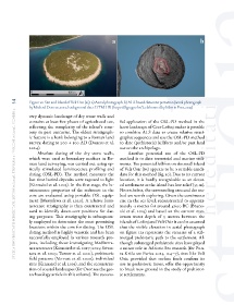
54     Figure 10: Site and Island of Veli Osir (65): a) Aerial photograph; b) ALS-based data interpretation (aerial photograph
               by Michael Doneus, 2012; background data: DTM HR (https://dgu.gov.hr/); elaborated by Martin Fera, 2025)
        studia universitatis hereditati, letnik 13 (2025), številka 2 / volume 13 (2025), number 2
               very dynamic landscape of dry stone walls and
               contains at least five phases of agricultural use,   ful application of the OSL-PD method in the
               reflecting the complexity of the island’s econ-  karst landscape of Cres-Lošinj makes it possible
               omy in past centuries. The oldest stratigraph-  to combine ALS data to create relative strati-
               ic feature is a bank belonging to a Roman land   graphic sequences and use the OSL-PD method
               survey, dating to 200 + 100 AD (Doneus et al.   to date (prehistoric) hillforts and/or past land
               2024).                                      use on the archipelago.
                   Absolute dating of the dry stone walls,     Another potential use of the OSL-PD
               which  were  used  as boundary markers in Ro-  method is to date terrestrial and marine sedi-
               man land surveying, was carried out using op-  ments. The potential hillfort on the small island
               tically stimulated luminescence profiling and   of Veli Osir (65) appears to be a suitable candi-
               dating (OSL-PD). The method measures the    date for this method (fig. 10). Due to its current
               last time buried deposits were exposed to light   location, it is hardly recognisable as an elevat-
               (Kinnaird et al. 2025). In the first stage, the lu-  ed settlement as the island has low relief (53 m).
               minescence  properties  of the sediment in  the   Nevertheless, the surrounding area and the sea-
               core are evaluated using portable OSL equip-  bed are worth exploring. Given the continuous
               ment (Munyikwa et al. 2020). A relative lumi-  rise in the sea level, reconstructed to approxi-
               nescence stratigraphy is then constructed and   mately -3 metres for around 4600 BC (Bruno-
               used to identify down-core positions for dat-  vić et al. 2019) and based on the current max-
               ing  purposes.  This  stratigraphy  is  subsequent-  imum water depth of 5 metres between the
               ly employed to determine the most promising   islands of Lošinj and Veli Osir it can be assumed
               locations within the core for dating. The OSL   that the visible elevation in aerial photograph
               dating method is highly versatile and has been   on figure 11a represents the remains of a sub-
               successfully employed in various research pro-  merged prehistoric path to the settlement. Al-
               jects, including those investigating Mediterra-  though submerged prehistoric sites have played
               nean terraces (Kinnaird et al. 2017; 2025; Srivas-  a minor role in Adriatic Sea research (for Pun-
               tava et al. 2023; Turner et al. 2021), prehistoric   ta Križa see Parica 2023, 124–7), sites like Veli
               field patterns (Vervust et al. 2020), individual   Osir, provided that surface finds confirm its
               sites (Kinnaird et al. 2019), and the reconstruc-  use in prehistoric times, offer the opportunity
               tion of coastal landscapes (for Osor see the geo-  to break new ground in the study of prehistor-
               archaeology article in this volume). The success-  ic settlements.