
Page 53 - Studia Universitatis Hereditati, vol 13(2) (2025)
P. 53
53
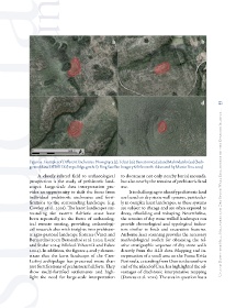
Figure 9: Examples of Different Enclosures: Novograjca (5), Telcar (10), Banestrovica (31) and Malondarski (49) (back-
ground data: DTM HR (https://dgu.gov.hr/); Bing Satellite Imagery © Microsoft; elaborated by Martin Fera, 2025)
A closely related field to archaeological to document not only nearby burial mounds,
prospection is the study of prehistoric land- but also nearby the remains of prehistoric land
scapes. Large-scale data interpretation pro- use.
vides an opportunity to shift the focus from It is challenging to identify prehistoric land Up and Down the Hill: Hillforts and Dry Stone Wall Enclosures on the Kvarner Islands...
individual prehistoric enclosures and forti- use based on dry stone wall systems, particular-
fications to the surrounding landscape (e.g. ly in complex karst landscapes, as these systems
Cowley et al. 2019). The karst landscapes sur- are subject to change and are often exposed to
rounding the eastern Adriatic coast have decay, rebuilding and reshaping. Nevertheless,
been repeatedly in the focus of archaeolog- the remains of dry stone walled landscapes can
ical remote sensing, providing archaeologi- provide chronological and typological indica-
cal research also with insights into prehistor- tors similar to finds and excavation features.
ic agro-pastoral landscape features (Vinci and Airborne laser scanning provides the necessary
Bernardini 2017; Bernardini et al. 2020; Lozić methodological toolkit for obtaining the rel-
and Štular 2024; Mlekuž Vrhovnik and Fabec ative stratigraphic sequence of dry stone walls
2024). In addition, the figures 4 and 7 demon- directly from the ALS data. Mapping and in-
strate that the karst landscape of the Cres- terpretation of a small area on the Punta Križa
Lošinj archipelago has preserved more than Peninsula, extending from Osor to the southern
just fortifications of prehistoric hillforts. They end of the island of Cres, has highlighted the ad-
show multi-fortified settlements and high- vantages of diachronic interpretative mapping
light the need for large-scale interpretation (Doneus et al. 2022). The area in question has a