
Page 146 - Studia Universitatis Hereditati, vol 13(2) (2025)
P. 146
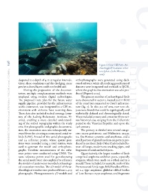
146                                                                  Figure 7: Osor, Old Port – Ar-

                                                                             chaeological Excavation in Sec-
        studia universitatis hereditati, letnik 13 (2025), številka 2 / volume 13 (2025), number 2
                                                                             tor 3 (photo: Jerko Macura,
                                                                             2023)
               deepened to a depth of 4 m at regular intervals.   orthophotographs were generated using dedi-
               Given these conditions and the dredging, more   cated software, while all resulting georeferenced
               precise cultural layers could not be defined.   datasets were integrated and overlaid in QGIS,
                   During the preparation of the documen-  where the graphic documentation was also pro-
               tation, multiple complementary methods were   duced (Popović 2023).
               employed using modern digital technologies.     The greatest number of archaeological finds
               The proposed route plan for the future water   were discovered in sector 3, located just in front
               supply pipeline, provided by the infrastructure   of the canal but connected to Osor’s infrastruc-
               works contractor, was integrated in a GIS en-  ture (fig. 7). In this 320 m² area, over 200 ob-
               vironment with airborne laser scanning data.   jects were found that could be typologically and
               These data also included seabed coverage (cour-  stylistically defined and chronologically dated.
               tesy of the Ludwig Boltzmann Institute, Vi-  These included pottery and container from vari-
               enna), enabling a more detailed understand-  ous historical eras, ranging from the Hellenistic
               ing of the seabed topography within the study   period to the Venetian Republic and up to the
               area. For photographic and graphic documenta-  19th century.
               tion, the excavation area was subsequently sur-  The pottery is divided into several catego-
               veyed from the air using an unmanned aerial ve-  ries: coarse prehistoric and Hellenistic ceram-
               hicle (UAV). A total of 867 aerial photographs   ics, fine Roman ceramics and amphorae, and a
               and 24 reference points, whose spatial posi-  small portion of glazed modern-era pottery pro-
               tions were recorded using a total station, were   duced in northern Italy. Other finds include Ro-
               used to generate the model and orthophoto-  man oil lamps, modern-era smoking pipes, and
               graphs. Geodetic measurements of the refer-  fragments of unidentified objects.
               ence points were conducted using GNSS. The      Quantitatively, the largest number of finds
               same reference points used for georeferencing   comprised amphorae and their parts, especially
               the aerial model were also employed to reference   stoppers, which were made on a wheel and in a
               the models of underwater-recorded archaeologi-  mould. These included, for example, necks of the
               cal excavation trenches. The 3D model of the ar-  Portorecanati/Unije type, bifid handles of Dres-
               chaeological trenches was produced from 2,409   sel 2-4 type amphorae, globular ribbed bodies
               photographs. Photogrammetric 3D models and   of Late Roman 1 type amphorae, and fragments