
Page 15 - Studia Universitatis Hereditati, vol 13(2) (2025)
P. 15
15
Dip Your Finger in the Sea...
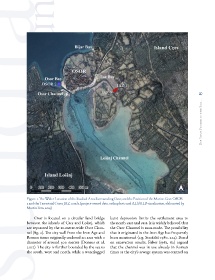
Figure 1: The Wider Location of the Studied Area Surrounding Osor, and the Position of the Marine Core OSOR
2 and the Terrestrial Cores JAZ 1 and 2 (project-owned data, orthophoto and ALS/ALB visualisation, elaborated by
Martin Fera, 2025)
Osor is located on a circular land bridge karst depression limits the settlement area to
between the islands of Cres and Lošinj, which the north-east and east. It is widely believed that
are separated by the 10-metre-wide Osor Chan- the Osor Channel is man-made. The possibility
nel (fig. 2). The city wall from the Iron Age and that it originated in the Iron Age has frequently
Roman times originally enclosed an area with a been mentioned (e.g. Stražičić 1980, 214). Based
diameter of around 300 metres (Doneus et al. on excavation results, Faber (1982, 62) argued
2017). The city is further bounded by the sea to that the channel was in use already in Roman
the south, west and north, while a waterlogged times as the city’s sewage system was centred on