
Page 19 - Studia Universitatis Hereditati, vol 13(2) (2025)
P. 19
19
Dip Your Finger in the Sea...
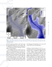
Figure 4: Digital Terrain Model (Combination of Slope and Hillshade) Derived from ALS/ALB Data (elaborated by
Doneus et al. 2017). Left: Underwater areas depicted in transparent blue colour. Right: Map of water depth in the Osor
and Lošinj Channel
ser scanner and especially on water clarity was the Italian government in the 1920s or 1930s and
up to 10 meters below the water surface. This is still visible in the ALB data (fig. 4).
is sufficient for interpreting coastal settlements
and identifying potential submerged archaeo- Multibeam and Sub-Bottom Sonar Survey
logical structures (fig. 4). Multibeam (MBES) bathymetry data were ob-
Knowledge about the detailed underwater tained during the survey of Osor Bay and Lošinj
relief is of crucial importance for research into Channel using a WASSP S3 MBES (Furu-
Osor, as it provides the maritime context neces- no ENL, Auckland, New Zealand), which was
sary for assessing its coastal setting. Although side-mounted on the MB Dide Rak. The vessel
the ALB-derived digital model only shows the was moving at a speed of approx. 3.5 knots. The
current underwater relief, it clearly illustrates MBES operational frequency was 160 kHz, pro-
the challenges posed by maritime traffic due ducing 224 beams in a 120-degree angle swath.
to the extremely shallow water depths. Today, The vessel positional data were provided using
small boats can navigate the Lošinj Channel due a Hemisphere V103 GPS GNSS antenna with
to dredging, which was probably carried out by SBAS motion corrections. The pitch, roll and