
Page 17 - Studia Universitatis Hereditati, vol 13(2) (2025)
P. 17
veys, stratigraphy, reconstruction of the depo- chronology spanning the past 5,000 years, high-
sitional environment, radiocarbon dating, and lighting the significance and temporal changes
evaluation of relative changes in sea level. of various human activities during Osor’s exist-
The Osor project builds on existing results ence as a settlement, as well as the impact of ris-
through a series of new geological and archaeo- ing sea levels.
logical investigations. The landscape-based ap-
proach introduced in 2012, which combined air- Case Study Area
borne laser scanning (ALS) and airborne laser Cres belongs, together with the islands of Lošinj,
bathymetry (ALB) surveys (Doneus et al. 2015), Krk and Rab, to the most northern group of
was crucial in this respect. Consequently, ALS Croatian islands. They are situated in the Kvarn-
data has provided a significant amount of in- er Bay, which is a semi-enclosed basin located be-
formation on human occupation in the dense- tween the Istria peninsula and the Vinodol-Ve-
ly overgrown areas of today. Furthermore, ALB lebit coast and encompasses numerous islands 17
has proven to be a valuable tool for rapidly scan- oriented parallel to the coastline (Dalmatian
ning the topography of shallow underwater are- type coast) (e.g. Benac et al. 2008a). The Kvarner
as (Doneus et al. 2013). Bay is part of the northern Adriatic shelf, which
The results of the geological ‘LoLADRIA’ is mostly shallow (up to 120 m) and low gradi-
project provided another important data set. ent (0.02°) continental shelf. Lithologically, the
The southeastern parts of the Lošinj Channel main units are Cretaceous carbonates deposit- Dip Your Finger in the Sea...
have been investigated at relatively low resolu- ed on the Adriatic/Dinaridic carbonate plat-
tion within the frame of the LoLADRIA project form (Pamić et al. 1998; Vlahović et al. 2005),
with a focus on the evolution of submerged karst overlain by Paleogene carbonates and siliciclas-
dolines (Brunović et al. 2019). These data provid- tic sediments. Accordingly, ~90% of the eastern
ed a starting point for a new study focusing on Adriatic coast is formed by carbonates, whilst
the geomorphological changes of the coastal area ~6% is formed in Eocene flysch (Pikelj and Ju-
in the shallow, NW part of the Lošinj Channel. račić 2013). All units were strongly deformed
The objective of this study was to reconstruct during the Eocene Dinarid (Alpine) orogenesis
the timeline of Osor and its surrounding areas and eventually uplifted during the latest moun-
by combining archaeological findings with ge- tain-building processes (Korbar 2009). Conse-
ochemical and geophysical data from the sedi- quently, late orogenic exhumation and Quater-
mentary records of Osor Bay. This multidiscipli- nary climate led to the formation of a classical
nary approach enabled the creation of a robust karst region – the Dinaric karst.
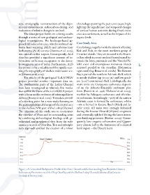
Figure 3: A Generalised Bathymetric Profile of the Osor Channel and the Surrounding Seas Shows the Distinct
Sedimentary Environments of the Deep Osor Bay and the Shallow Lošinj Channel (elaborated by Croatian
Geological Survey, 2025)