
Page 125 - Studia Universitatis Hereditati, vol 13(2) (2025)
P. 125
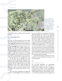
Figure 3: NW Part of
                                                                                   the Roman Osor in the
                                                                                   Results of the Ground
                                                                                   Penetrating Radar Sur-
                                                                                   vey 2023–24 Indicating
                                                                                   the Layout of the City,
                                                                                   Including the Streets   125
                                                                                   and Insulae (elaborat-
                                                                                   ed by Geosphere Aus-
                                                                                   tria, 2024)

               dieval architecture (e.g. Bully and Čaušević-Bul-  have also enabled the stratigraphic information
               ly 2012).                                   contained within the airborne laser scanning
                                                           data surrounding Osor to be analysed. Based on
               Recent Research Results                     the relative chronology of the dry stone walls out-
               Osor                                        side the city limits, evidence of a Roman system
               Research into the landscape of the Osor region   of dry stone walls was discovered (Doneus et al.
               has been ongoing since 2012 (Doneus et al. 2015).   2022). These features were dated using the OSL
               After large-scale geophysical measurements in   profiling and dating method (OSL-PD), which
               2014/15 (Doneus et al. 2017), Osor was the focus   yielded a date range of AD 200 ± 100 (Doneus et  The Roman Urbanisation of the Northern Adriatic Island of Cres
               of a second geophysical survey in autumn 2023/  al. 2024). Furthermore, there is an obvious spa-
               spring 2024. The results, which are being pre-  tial connection between the layout of the Roman
               pared for publication, provide an insight into the   Osor and land surveying, as the boundary lines
               NW-SE oriented street grid of a small town with   of the surveying system are oriented according to
               a diameter of about 300 m and the insulae meas-  the city’s location, considering the location of the
               uring 1 x 2 actus (fig. 3). The forum was situated   forum, where the umbilicus (the intersection of
               in the SW of the city, and its location was con-  the survey axes) may be assumed.
               firmed during archaeological rescue excavations   Overall, these results provide the first clear
               in the main square in 2022–24 (Baričević 2023).   evidence of municipal land surveying on the
                   To the west, the city borders the Osor   Croatian islands.
               Channel, which separates the islands of Cres
               and Lošinj, providing a navigable route between   Beli
               Osor Bay and the Lošinj Channel to the south.   Archaeological Prospection
               A separate article in this volume discusses the   The successful application of archaeologi-
               importance of the Osor Channel for (Roman)   cal prospection methods in the evaluation of
               shipping, as well as the issues related to coast-  Roman cities hinges on the use of appropri-
               al changes and the presumed location of city   ate techniques, as well as on the topographical
               harbours.                                   conditions and the state of preservation of the
                   In recent years, systematic and large-scale   archaeological structures. For example, Osor is
               analyses  of archaeological  remote  sensing  data   an extremely favourable location for geophysical