
Page 126 - Studia Universitatis Hereditati, vol 13(2) (2025)
P. 126
126
studia universitatis hereditati, letnik 13 (2025), številka 2 / volume 13 (2025), number 2
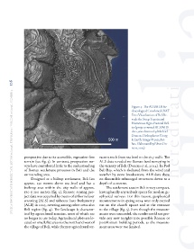
Figure 4: The ALS/ALB Ar-
chaeological Combined cVAT
Data Visualisation of Beli Re-
veals the Steep Terrain and
Numerous Agro-Pastoral Rel-
ics (project-owned ALS/ALB
data, visualisation by Michael
Doneus, Orthophoto: Goog-
le Earth. Image © 2025 Air-
bus. Elaborated by Nives Do-
neus, 2025)
prospection due to its accessible, vegetation-free races stretch from sea level to the city walls. The
terrain (see fig. 3). In contrast, prospection sur- ALS data revealed no Roman land surveying in
veys have contributed little to the understanding the vicinity of Beli (Doneus et al. 2024). In Pod
of Roman settlement processes in Beli and the Beli Bay, which is sheltered from the wind and
surrounding area. weather by stone breakwaters, ALB data show
Designed as a hilltop settlement, Beli lies no discernible submerged structures down to a
approx. 130 metres above sea level and has a depth of 10 metres.
built-up area within the city walls of approx. The settlement area in Beli is very compact,
170 x 100 metres (fig. 2). Remote sensing pro- leaving hardly any unbuilt spaces for modern ge-
ject data was acquired by means of airborne laser ophysical surveys. For this reason, geophysical
scanning (ALS) and airborne laser bathymetry measurements in spring 2024 were only carried
(ALB) in 2023, covering among other areas also out on the church square and at the entrance
Beli region (fig. 4). The landscape is character- to the village (fig. 5). Even though the measure-
ised by agricultural remains, most of which are ments were successful, the results could not pro-
no longer in use today. Agricultural plots are lo- vide any new insights into possible Roman or
cated on small, flat areas to the north and west of post-Roman building periods, as the measure-
the village of Beli, while former agricultural ter- ment areas were too limited.