Page 106 - Studia Universitatis Hereditati, vol. 5(2) (2017)
P. 106
and low illumination gained 3D models can es exactly the position of the scanner. But Leica
be rotated and measured in the virtual space and BLK360 scanner has three HDR cameras with
can be used for different purpose. 15 mp, with LED flashlights, together result-
ing with full dome capture a 150-mp, providing
a 360-degree horizontally and 300 degrees ver-
tically coverage.16 A BLK360, has a blind spot
directly underneath, that spot is replete with
points from the second scan made from anoth-
er point. Gained 3D model can aid further anal-
ysis, as it provides us with vertical and horizon-
tal cross-sections of the space, as well as precise
measurements of the building, which are signif-
icant for calculating and reconstruction the ar-
chitectural plans.
studia universitatis her editati, letnik 5 (2017), številk a 2 106
hereditati
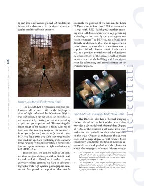
Figure 7. Leica BLK 360 (foto by Nenad Jončić) Figure 8. 3D model of dungeons (foto by Nenad Jončić)
The Leica BLK360 represent a compact pro-
The BLK360 also has a thermal imaging
fessional 3D scanner, utilizes the high-speed camera placed on the back of the device, that
time of light enhanced by Waveform Digitiz- provides a 3D model with thermal data (Figure
ing technology. Scanner emits an invisible la- 9).17 One of the results is a 3D model with ther-
ser beam sent by rotating mirror at a rate of up mal areas that can indicate the level of moisture
to 360,000 points per second. The working dis- in the walls (Figure 5), indicating the current
tance range of the scanner is from 0.6m up to state and damage degree of wall mortar. More
60m and the accuracy range of the scanner is specifically, it indicates the level of moisture re-
from 4mm (at 10m) to 7mm (at 20m). Leica sponsible for the degradation of the plaster on
BLK 360 have three available scanning modes; which the messages are located. Moisture caus-
low, medium and high resolution, with scanning
times ranging from approximately 2 minutes for 16 Leica Geosystems AG. 2018. https://lasers.leica-geosystems.com/
low, and up to 7 minutes in high resolution and global/sites/lasers.leica-geosystems.com.global/files/leica_me-
full HDR colour. dia/product_documents/blk/17-lei-030_blk360_spec_sheet_
r2_v2.pdf (accessed june 15, 2018)
In most cases, the camera built in the scan-
ner does not provide images with sufficient qual- 17 Leica Geosystems AG. 2018. https://lasers.leica-geosystems.com/
ity and resolution. Therefore, in order to create global/sites/lasers.leica-geosystems.com.global/files/leica_me-
correctly colored textures, we have to take pho- dia/product_documents/blk/17-lei-030_blk360_spec_sheet_
tographs with high-quality photographic cam- r2_v2.pdf (accessed june 15, 2018)
era and lens placed in the position that match-
be rotated and measured in the virtual space and BLK360 scanner has three HDR cameras with
can be used for different purpose. 15 mp, with LED flashlights, together result-
ing with full dome capture a 150-mp, providing
a 360-degree horizontally and 300 degrees ver-
tically coverage.16 A BLK360, has a blind spot
directly underneath, that spot is replete with
points from the second scan made from anoth-
er point. Gained 3D model can aid further anal-
ysis, as it provides us with vertical and horizon-
tal cross-sections of the space, as well as precise
measurements of the building, which are signif-
icant for calculating and reconstruction the ar-
chitectural plans.
studia universitatis her editati, letnik 5 (2017), številk a 2 106
hereditati
Figure 7. Leica BLK 360 (foto by Nenad Jončić) Figure 8. 3D model of dungeons (foto by Nenad Jončić)
The Leica BLK360 represent a compact pro-
The BLK360 also has a thermal imaging
fessional 3D scanner, utilizes the high-speed camera placed on the back of the device, that
time of light enhanced by Waveform Digitiz- provides a 3D model with thermal data (Figure
ing technology. Scanner emits an invisible la- 9).17 One of the results is a 3D model with ther-
ser beam sent by rotating mirror at a rate of up mal areas that can indicate the level of moisture
to 360,000 points per second. The working dis- in the walls (Figure 5), indicating the current
tance range of the scanner is from 0.6m up to state and damage degree of wall mortar. More
60m and the accuracy range of the scanner is specifically, it indicates the level of moisture re-
from 4mm (at 10m) to 7mm (at 20m). Leica sponsible for the degradation of the plaster on
BLK 360 have three available scanning modes; which the messages are located. Moisture caus-
low, medium and high resolution, with scanning
times ranging from approximately 2 minutes for 16 Leica Geosystems AG. 2018. https://lasers.leica-geosystems.com/
low, and up to 7 minutes in high resolution and global/sites/lasers.leica-geosystems.com.global/files/leica_me-
full HDR colour. dia/product_documents/blk/17-lei-030_blk360_spec_sheet_
r2_v2.pdf (accessed june 15, 2018)
In most cases, the camera built in the scan-
ner does not provide images with sufficient qual- 17 Leica Geosystems AG. 2018. https://lasers.leica-geosystems.com/
ity and resolution. Therefore, in order to create global/sites/lasers.leica-geosystems.com.global/files/leica_me-
correctly colored textures, we have to take pho- dia/product_documents/blk/17-lei-030_blk360_spec_sheet_
tographs with high-quality photographic cam- r2_v2.pdf (accessed june 15, 2018)
era and lens placed in the position that match-