Page 20 - Studia Universitatis Hereditati, vol 9(2) (2021)
P. 20
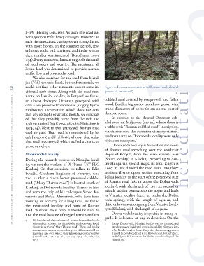
dia universitatis her editati, letnik 9 (2021), številk a 2 / volume 9 (2021), number 2 208-16% (Herzog 2013, 186). As such, this road wasFigure 11. Dobra voda, condition of Roman road as found
not appropriate for heavy carriages. However, in (photo M. Imamović).
hereditatisuch circumstances, carriages were strengthened
with more horses. In the summer period, few- cobbled road covered by overgrowth and fallen
er horses could pull carriages, and in the winter, wood. Besides, big spruce trees have grown with
their number was increased (Berechman 2003, trunk diameters of up to 60 cm on the part of
474). Every transport, human or goods demand- the road route.
ed total safety and security. The maximum al-
lowed load was determined to provide normal In contrast to the cleaned Ottoman cob-
traffic flow and protect the road. bled road on Miljkovac (130 m), where there is
a table with “Roman cobbled road” inscription,
We also searched for the road from Metal- which attracted the attention of many visitors,
jka (Vrh) towards Pauč, but unfortunately, we road remnants on Dobra voda locality were only
could not find other remnants except some in- visible on rare spots.8
cidental curb stone. Along with the road rem-
nants, on Lanište locality, in Potpauč we found Dobra voda locality is located on the route
an almost destroyed Ottoman graveyard, with of Roman road stretching over the southeast
only a few preserved tombstones. Judging by the slopes of Konjuh, from the Stara Karaula pass
tombstones architecture, which does not con- (Solara locality) to Kladanj. According to Aus-
tain any epitaphs or artistic motifs, we conclud- tro-Hungarian special maps, its total length is
ed that they probably come from the 16th and 5.667 m. We divided the road route into three
17th centuries (Bejtić 1953, 285-289; Mujezinović sections: first or upper section stretching from
1974, 14). Next to this graveyard, Roman road Solara locality to the start of the preserved part
used to pass. That road is remembered by lo- of Roman road (285 m above the Dobra voda
cals Jusupović and Halilović, who say that today locality), with the length of 1.903 m; second or
that road is destroyed, which we had a chance to middle section connects to the upper and leads
prove ourselves. to Vratnica locality (1.247 m under the Dobra
voda spring), with the length of 1.532 m; and
Dobra voda Locality third or lower section going from Vranica locali-
During the research process on Metaljka local- ty to Kladanj, with the length of 2.232 m.
ity, we met the workers of PI “Šume TK” PLC
Kladanj. On that occasion, we talked to Edin Dobra voda locality is specific in many re-
Šuvalić, Graduate Engineer of Forestry, who gards. It is located at 929 m elevation. On the
told us that a much better preserved cobbled
road (“Mary Theresa road”)7 s located south of 8 Except Dobra voda, Metaljka locality was not cleaned, and
Kladanj, at Dobra voda locality. Thanks to him only because of incidental stones, it could be glimpsed into
and with the help of his colleagues Senad Ka- what kind of road is there. Only after the cleaning process
vazović and Rešad Ahmetović, who have been it could be concluded that it is a Roman road. In the future,
working in Forestry for a long time, we found probably the full route on the Dobra voda locality will be
the mentioned locality and route of Roman cleaned up.
road. Without their help, it would be hard to
find the road because of rugged terrain and the
7 We have heard almost identical stories from other locals,
who in their accounts for the cobbled roads on other local-
ities, told us that is “Mary Theresa road“. These and similar
accounts are present in the other parts of Bosnia and Her-
zegovina, and even wider, in neighbouring countries (Bo-
janovski 1981, 132, 159, 164, 170-175; 1984, 160, 167, 169-
171).