Page 18 - Studia Universitatis Hereditati, vol 9(2) (2021)
P. 18
dia universitatis her editati, letnik 9 (2021), številk a 2 / volume 9 (2021), number 2 18liable testimony that Romans populated the areaFigure 7. Metaljka, cleaned Roman road
of modern Kladanj municipality in their times. (photo M. Imamović).
hereditati
Save from the single incidental gold coin Figure 8. Metaljka, cleaned Roman road
Pulcheria - originating from the Eastern Roman (photo M. Imamović).
Empire (first half of 5th century AD), found in remaining section, due to centuries-old vegeta-
the 19th century (Patsch 1900, 562), other relics tion and forest exploitation, it is pretty devastat-
from the Antic Age have not been found so far. ed and destroyed.
In his description of eastern Bosnia, Bojanovski
put a particular accent on rich forests, thinking Intensified forest exploitation required the
of Konjuh and Zvijezda mountains. Regarding construction of so-called forest roads used for
that he says ”there are almost no signs of Roman wood transport. Because of such circumstanc-
material culture” and that these areas “especial- es, on the road leading from Metaljka locality to-
ly Drinjača valley are not examined very well ar- wards Usjelina, the road is intersected by a forest
chaeologically” (Bojanovski 1982, 129, note 10), road. Above the road, well-preserved parts were
even though Drinjača was the second most im- found, while beneath the road, in the length of
portant traffic hub for Salona-Argentaria high- 55 m, only the devastated remnants of the Ro-
way after the Drina (Imamović 1985, 43). man road were found. This section of the road is
visible, and there are scattered remains of stone
Unfortunately, even later, there was no im- slabs here. Also, only rare scattered remnants
provement regarding scientific research. How- were found on the next section going all the way
ever, we believe that these localities and found to Usjelina locality.
remnants of Roman road communications will
start the new archaeological examinations in the
future.
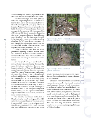
On Metaljka locality, we found road rem-
nants, which were considerably destroyed be-
cause of the forest exploitation. The road came
from the direction of Pauč and Kladanj settle-
ments. It stretched in the direction east-north-
west. Two types of limestone were used to pave
the carrier layer, larger for the curbs and small-
er for the middle part. The margin stones (curbs)
vary, ranging from 35 cm to 53 cm long, 23 cm
to 41 cm wide and 10 cm to 15 cm high. Small-
er stones were installed between the two curbs,
with sizes from 10 cm to 32 cm long; 10 cm to 23
cm wide and 10 cm to 13 cm high. The height of
the embankment on the Metaljka locality varies
from 15 cm to 54 cm. The highest measured slope
angle was 28% in the south-western part and 11%
in the north-eastern part.
The measured and cleaned road section on
Metaljka locality is 51.80 m long, and its width
varies from 2.50 m and 2.90 m. This road section
is only partially preserved in its original condi-
tion. On some sections, in its middle construc-
tion part, cobblestones are missing, and on the
of modern Kladanj municipality in their times. (photo M. Imamović).
hereditati
Save from the single incidental gold coin Figure 8. Metaljka, cleaned Roman road
Pulcheria - originating from the Eastern Roman (photo M. Imamović).
Empire (first half of 5th century AD), found in remaining section, due to centuries-old vegeta-
the 19th century (Patsch 1900, 562), other relics tion and forest exploitation, it is pretty devastat-
from the Antic Age have not been found so far. ed and destroyed.
In his description of eastern Bosnia, Bojanovski
put a particular accent on rich forests, thinking Intensified forest exploitation required the
of Konjuh and Zvijezda mountains. Regarding construction of so-called forest roads used for
that he says ”there are almost no signs of Roman wood transport. Because of such circumstanc-
material culture” and that these areas “especial- es, on the road leading from Metaljka locality to-
ly Drinjača valley are not examined very well ar- wards Usjelina, the road is intersected by a forest
chaeologically” (Bojanovski 1982, 129, note 10), road. Above the road, well-preserved parts were
even though Drinjača was the second most im- found, while beneath the road, in the length of
portant traffic hub for Salona-Argentaria high- 55 m, only the devastated remnants of the Ro-
way after the Drina (Imamović 1985, 43). man road were found. This section of the road is
visible, and there are scattered remains of stone
Unfortunately, even later, there was no im- slabs here. Also, only rare scattered remnants
provement regarding scientific research. How- were found on the next section going all the way
ever, we believe that these localities and found to Usjelina locality.
remnants of Roman road communications will
start the new archaeological examinations in the
future.
On Metaljka locality, we found road rem-
nants, which were considerably destroyed be-
cause of the forest exploitation. The road came
from the direction of Pauč and Kladanj settle-
ments. It stretched in the direction east-north-
west. Two types of limestone were used to pave
the carrier layer, larger for the curbs and small-
er for the middle part. The margin stones (curbs)
vary, ranging from 35 cm to 53 cm long, 23 cm
to 41 cm wide and 10 cm to 15 cm high. Small-
er stones were installed between the two curbs,
with sizes from 10 cm to 32 cm long; 10 cm to 23
cm wide and 10 cm to 13 cm high. The height of
the embankment on the Metaljka locality varies
from 15 cm to 54 cm. The highest measured slope
angle was 28% in the south-western part and 11%
in the north-eastern part.
The measured and cleaned road section on
Metaljka locality is 51.80 m long, and its width
varies from 2.50 m and 2.90 m. This road section
is only partially preserved in its original condi-
tion. On some sections, in its middle construc-
tion part, cobblestones are missing, and on the