
Page 21 - Studia Universitatis Hereditati, vol 13(2) (2025)
P. 21
21
Dip Your Finger in the Sea...
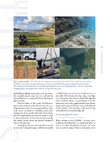
Figure 6: Surveys of the Osor Channel: a) Geophysical survey of both sides of the channel: b) Underwater survey;
c)–d) Cores were retrieved using a Niederreiter Piston Corer (UWITEC, Austria) and platform in Osor Bay;
e) Coring locations for the three cores (a) elaborated by Martin Fera, 2025; b) elaborated by Croatian Conservation
Institute, 2023; c–e) elaborated by Croatian Geological Survey, 2024)
nel had been rebuilt many times over the centu- er (SBP) shows several metres of sediment on ei-
ries, and the area between the city wall and the ther side of the channel (see fig. 3, fig. 5, and figs.
channel had been completely filled in during the 6c–e). However, the seismic profile through the
last 100 years. Osor Channel shows no penetration into the
Osor has been at the centre of infrastruc- subsurface due to the tightly packed layer of sed-
tural modernisation since the summer of 2022. iment and stones of different sizes at the bottom
Construction work was accompanied by large- of the channel. This was also confirmed during
scale rescue excavations, including underwater the underwater excavation (fig. 6b).
excavations at the south end of the Osor Chan-
nel. This opportunity was used to conduct a vid- Geoarchaeological Research
eo documentation of the channel ground (fig. Coring and Lithological Description
6b), which clearly shows the modern mortared Three sediment cores (OSOR 1–3) were recov-
sides of the channel. ered from Osor Bay (fig. 1) at depths between 30
The high-resolution seismic profile acquired and 40 m below the present sea level. The cores
in the Osor Channel using a sub-bottom profil- were retrieved using a Niederreiter piston corer